The Bond Fire evacuation map does not indicate any evacuations in Irvine at this time, per the Irvine Police Department.
In a Tweet, the Irvine Police Department addressed concerns about Irvine residents receiving an evacuation order, even though the city of Irvine was not under any direct order to evacuate or prepare to evacuate.
We received reports that some of our citizens received alert evacuation orders for the #Bondfire. There are currently no evacuation orders for Irvine. Please follow @OCFA_PIO for the most up to date information.
— Irvine Police Department (@IrvinePolice) December 3, 2020
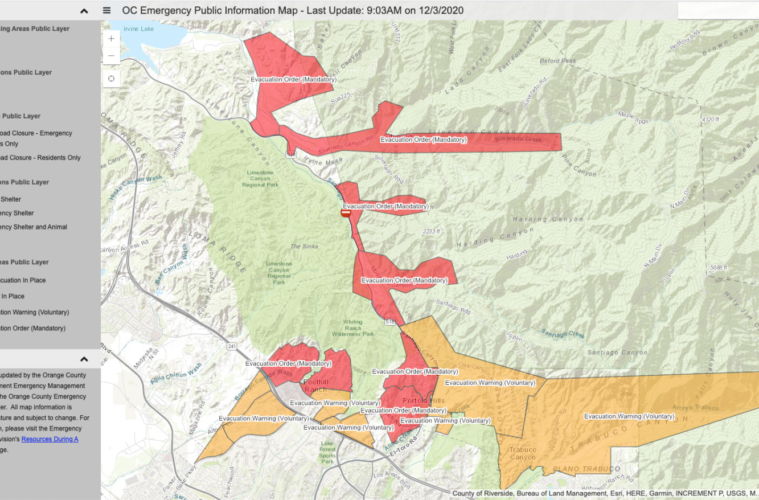
While the Bond Fire burning in Silverado Canyon has not promoted any evacuation orders for the city of Irvine, the Orange County Fire Authority has released an interactive evacuation map for all areas affected.
Unsure if you should evacuate? @OCSheriff has provided a real-time, interactive evacuation map for residents: https://t.co/gLIdjRyYtb pic.twitter.com/mdM7ckqQS9
— OCFA PIO (@OCFA_PIO) December 3, 2020
Cal Fire and OCFA are the two agencies working to battle the Bond Fire in Irvine’s Silverado Canyon. The blaze is now more than 3,600 acres. The Bond Fire began on Wednesday, Dec. 2 around 11:00 p.m., when a structure fire reached near by vegetation, according to Tweets from the OCTA.
New Incident: #BondFire in Silverado Canyon in Orange County is 3643 acres. Unified Command: CAL FIRE, @OCFA_PIO, and USFShttps://t.co/rSU4aH7NwE pic.twitter.com/U0bFiywJL9
— CAL FIRE (@CAL_FIRE) December 3, 2020
The fire was started after flames from a structure fire in Silverado Canyon reached dry vegetation. The blaze prompted mandatory evacuations for Foothill Ranch and Portola Hills west of El Toro and North of 241 Toll Road.
Voluntary evacuation orders were put in place for Borrego Canyon, Foothill Ranch, Baker Ranch, Portola Hills, Live Oak Canyon, Trabuco Canyon, Rose Canyon, and Valley Vista Way and Meadow Ridge Drive, early Thursday on Dec. 3.
The Bond Fire is now the second wind-driven wildfire to hit Silverado Canyon this year. In October, the Silverado Fire burned more than 12,000 acres and caused the evacuation of more than 90,000 residents between Irvine and Lake Forest.
There are more than 500 firefighters currently battling the blaze, with air support excepted throughout the day.
Advertising disclosure: We may receive compensation for some of the links in our stories. Thank you for supporting Irvine Weekly and our advertisers.